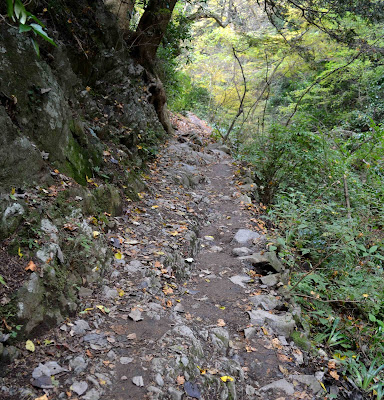
Part of the reason I moved to Takao is due to Mount Takao and the surrounding mountain trails. More and more I find myself losing interest in running on flat, paved roads. Whereas my desire to run on challenging, technical trails is unquenchable. I have discovered a lot of terrific trails in the area, but my absolute favorite by far is Trail 6 on Mt. Takao.
Trail #6 offers gorgeous scenery, dramatic elevation changes, very technical single path, surface changes, and a stunning view at the end. Additionally, at 2.36 miles from base to summit, it's long enough to provide a decent workout. It's easy to tack it onto the beginning, middle, or end of a longer run as well. Because of the trail's difficulty, it's always less crowded than Takao's more popular routes.
Since arriving in Japan, I have been improving my uphill running stamina, mainly so I can partake in my favorite trail running discipline: Descents. I've never considered myself a top runner--not even in my age group. But I like to think I'm somewhat of what I call a Downhill Specialist. That is I can cover the distance from top to bottom faster than most people, especially if the trail is particularly nasty.
It's for this reason that I love Trail #6. It has the perfect blend of runability combined with challenging terrain. The steepness allows you to keep your speed up without blowing out your knees on an out-of-control descent. The trick is to run it as fast as possible without maiming yourself. It's hard to say how close I've come to hitting that mark, but I've been timing myself to track my progress. 17 minutes, 20 seconds is my best time to date. I haven't timed myself going up, but I plan to.
***Update: Feb 8, 2013
Today I ran up in 33:14, which is about my usual. I set a new record coming down of 16:49.***
In creating this post, I desire to be the web's top destination for Trail 6. I shot a ton of pictures last week in preparation for this post. I whittled those down to just under 50. I was going to break them up into several smaller posts, but then I decided I wanted them all available in one link. So I apologize in advance for the length of this entry. Here we go.
For most hikers looking to visit Mt. Takao, their first stop will be the Keio Takao train station, accessible from the JR station next door. Looking South from the upper platform, you can see another favorite area of mine to run, the trails surrounding the golden tower.
The first of 2 tunnels you'll pass through en route to Mt. Takao.
Exiting at Takaosanguchi Station, located at the base of Mt. Takao.
The big trail map showing the various routes to and around Mt. Takao.
These photos are representative of the area in Autumn. The second most popular time to visit Mt. Takao after Spring/Cherry Blossom Season.
The tram is supposed to be a swell means of reaching the top. I wouldn't know.
The trail head for Nature Reserve Trail No. 6 at Mt. Takao. Located up the road, on the left, after the tram station.
View from the trail head. It starts out with a gentle incline on a wide path.
A little ways up you'll need to split off to the left, through the poles.
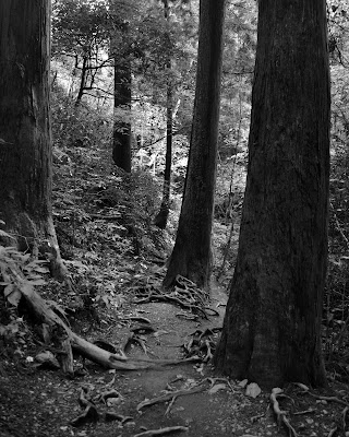
Soon after, things get trickier. The network of roots on this trail are my favorite feature.
The path is usually worn down in and around the roots.
There are several small bridge crossings, including Oyama Bridge. I've learned the hard way that these wooden bridges are extremely slippery when wet, especially if you hit them at speed on a sharp turn.
The rocks can also be slippery after a rainstorm, so watch where you plant your feet.
Remember: high knees
Although there is often a smooth trail besides the rooty mess, that area is often occupied by slow hikers, driving me into the root maze in order to pass. I'm afraid of hurting someone else on this trail as much as I am of hurting myself.
Unless it's one of these tar suckers taking a smoke break. Nothing clears the lungs like cigarette smoke in nature. Where's a good rock slide when you need one.
Up the stream bed. The amount of water varies on season and rainfall. Careful for mossy rocks.
It feels like the stairs are never-ending.
So this timely rest area is a good place to recover.
Follow the short paved path
Turn left at the restrooms
And make the final push to the summit.
It can be completely empty or twice as crowded as this at the summit, depending on when you arrive. Winter and summer are good times to have the place to yourself.
This drinking fountain has been a welcome sight on many occasion. I usually don't carry water on my runs.
Looking back down the way I came from the summit. This is where I start my watch for my timed descents back to the big trail map.
Just before the grand staircase there are lots of these caution signs posted. I assume they say "watch your step", but I'm probably wrong.
I try and get into a rhythm when running down the steps, never taking my eyes off the 4 or 5 in front of me.
Entrance to the stream section of the trail.
There is a fork at the end of the stream section. Keep to the left.
The trail follows a stream most of the way down. Here it's off to your right.
Tricky roots followed by a sharp right turn across a bridge.
A black and white shot
A muddy section
More roots
The groomed area near the exit
Sights along the road back to the base
Just after the tram area, there's a fork in the road. Take the left again.
A closeup of the huge Mt. Takao trail map. This is where I stop my watch. Time to beat--16:49.
Arriving back at Keio Takao station.
7 years ago


6 comments:
You are so right about the never ending stairs.
Shane! Happy birthday today! What is your email?
Nicole
Hi Nicole. I was thinking about you the other day and sad that we aren't in regular contact. Your fault, not mine:)
You can reach me at japanshane at gmail or re-friend me on Facebook.
Those are some tricky roots, looks like fun.
Great info! Im heading up there on Tuesday for a run - it will be busy but looking forward to it after reading this! :)
Good luck Jacob, let me know how it went. I miss that trail.
Shane
Post a Comment